Projects

There are several smart mobility projects and pilots ongoing and completed in Helsinki - primarily focused in the West Harbour area and Jätkäsaari. The different cases include smaller experiments as well as bigger projects with different research aspects (e.g. EU projects).
Kalasatama area Photo: Suomen Ilmakuva Oy

Development of a digital twin for mobility

Companies: Gispo Oy, Webion Oy, Sitowise Oy

The objective of the agile pilots is to serve the overall development of the city of Helsinki’s digital twin. 

Goal: The goal is to explore and test new methods, such as artificial intelligence, for the information modelling of the current state of street environments and street asset management. 

Schedule: 1/2024-3/2024 

Contact: Jussi Knuuttila, jussi.knuuttila@forumvirium.fi 

In Gispo‘s experiment, the goal is to increase the potential use of the city’s 3D materials by enabling the utilisation of 3D data in QGIS for a wider user base within the city organisation. 

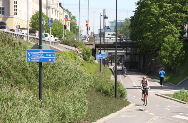
Webion participates in the experiment with the aim of developing the measurement of urban spaces. The technologies in the experiment can be used in the future to produce measurements of urban spaces that promote the development of digital twins of cities as well as maintenance. In the experiment, among other things, street-level imagery is refined using artificial intelligence. 

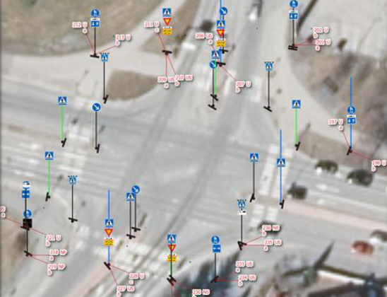
Sitowise is developing a new and easily scalable method in which data from various traffic infrastructure sources is analysed and classified automatically using commercial tools and artificial intelligence algorithms. 

The results of the pilot procurement will be used for the implementation of the CityGML 3.0 street environment test data in 2024. 

Esplanade Park Photo: Lauri Rotko

Lidar pilot on Esplanadi in Helsinki 

Companies: FlowAnalytics 

Researching traffic behaviour on Esplanadi, Helsinki, during street reorganisation experiment by the city of Helsinki on the Eteläesplanadi and Pohjoisesplanadi streets.

Goal: To gather traffic data and analyse traffic behaviour for improving area safety and attractiveness. 

Schedule: 11/2023 - fall 2024 

Contact: Jussi Knuuttila, jussi.knuuttila@forumvirium.fi 

The project involves using light radar technology (lidar) to gather data on vehicles, bicycles, electric scooters, and pedestrians. The aim is to understand the impact of the changes on the Esplanadi on traffic flow and traffic behaviour.  

Aleksanterinkatu Photo: Jussi Hellsten

Three-dimensional modeling: street environment

Companies: Sitowise Oy, Zero Gravity Oy 

Seeking new ways to produce a 3D surface models of the street environment.

Goal: The objective of the open call was to produce 3D surface models of the street environment, as well as ensuring that it is significantly more detailed than the City's current two-dimensional materials. 

Schedule: 03/2023-05/2023

Contact: Matias Oikari, matias.oikari@forumvirium.fi 

In a pilot conducted by Sitowise, the goal was to produce a 3D model of the urban environment, which can be utilized in examining various modes of transportation environments in Helsinki. The method used in the pilot was a continuation of Sitowise’s work created in the spring of 2022, where a tool was developed using the FME conversion process to transform road features from the General Area Registry (YLRE) into CityGML format. 

Zero Gravity was developing a way to combine existing City of Helsinki data on traffic areas with manual labelling for the training dataset as well as creating a segmentation model to extend to the rest of pilot area.


Traffic signs next to bike path

Traffic signs – identifying and updating changes

Company:  Marjetas Academy

This pilot tests an agile solution for updating and maintaining changes and data about traffic signs. Marjetas Academy uses the Street Hive solution to identify changes compared to previously collected data by using 360 visual analytics.

Schedule: 10-12/2022

Contact: Janne Rinne (Forum Virium Helsinki)

The pilot with Marjetas Academy is one of the agile pilots selected in Oct 2022 (read more in Finnish) which aim to support the development of Helsinki’s cityinfra platform.

Picture with lots of traffic signs at an intersection

Traffic signs – analysing reality vs. plans

Company: Normiopaste Oy

This pilot uses 360 machine vision for collecting accurate data about traffic signs. The focus is especially on the means for comparing reality with plans (i.e. where traffic signs are compared to where plans say they are).

Goal: Mapping reality of traffic sings compared to plans

Schedule: 10-12/2022

Contact: Janne Rinne (Forum Virium Helsinki)

The pilot with Normiopaste is one of the agile pilots selected in Oct 2022 (read more in Finnish) which aim to support the development of Helsinki’s cityinfra platform.

Drone path

Drone delivery service

Third Space Auto, Fly-By Guys

Finished Q4/2021 Drone-based delivery services to the district of Jätkäsaari. The pilot test both the feasibility and usefulness as well as citizens' views about using drones as a means for delivering items.

Goal: Testing the usefulness of drone deliveries

Contact: Matias Oikari (Forum Virium Helsinki)

This pilot is one of the selected agile pilots from the call in the summer of 2020.

InnoTrafik's sensor capsule

Smart pedestrian warning system for the visually impaired

InnoTrafik

Finished Q2/2021 A smart warning system for the visually impaired at pedestrian crossings.

Goal: Testing the feasibility of a warning system for the visually impaired

Contact: Janne Rinne (Forum Virium Helsinki)

This project is one of the selected agile pilots. The solution will be tested in the spring of 2021 as the first phase of the agile pilot process.

Trombia's autonomous street sweeper

Autonomous street sweeper

Trombia Technologies

Piloting Trombia's autonomous and energy efficient street sweeper as a street maintenance solution together with street maintenance experts from Stara and the City of Helsinki.

Goal: Testing the feasibility of an autonomous street sweeper

Contact: Janne Rinne (Forum Virium Helsinki)

This project is one of the selected agile pilots. The solution was tested in the spring of 2021 as the first phase of the agile pilot process, the second phase of the pilot is planned for spring of 2022.

Screenshot of TerrainSense platform with data from Jätkäsaari

Bike path condition measurement

TerrainSense

Finished Q2/2021 Measuring the condition of bike paths with sensors installed in bicycles to monitor issues and maintenance levels.

Goal: Testing the use of bike-mounted sensors for bike path condition measurement

Contact: Janne Rinne (Forum Virium Helsinki)

This project is one of the selected agile pilots. The solution was tested in the spring of 2021 as the first phase of the agile pilot process.

Dangerous driving behaviour at pedestrian crossing

Near miss detection at pedestrian crossings

Kradient Intelligence

Finished Q2/2021 Detection of near miss events at pedestrian crossings by using machine vision.

Goal: Testing the detection of dangerous driving behaviour at pedestrian crossings

Contact: Janne Rinne (Forum Virium Helsinki)

This project is one of the selected agile pilots. The solution was tested in the spring of 2021 as the first phase of the agile pilot process.