Projects

There are several smart mobility projects and pilots ongoing and completed in Helsinki - primarily focused in the West Harbour area and Jätkäsaari. The different cases include smaller experiments as well as bigger projects with different research aspects (e.g. EU projects).
Concept depicting vehicles communicating with infrastructure and one another in an intersection

SmartEdge

Aalto University Conveqs Oy

EU project looking at vehicle-to-infra (V2X) solutions to improve traffic safety.

Improving traffic safety, developing C-ITS solutions

01/2023-12/2025

Juho Kostiainen, Business Helsinki

Project website

https://www.smart-edge.eu/

In the Jätkäsaari area, utilising the smart infra from the Smart Junction project, piloting of C-ITS solutions with a couple traffic lights and vehicles. Demonstrations planned for 2025 after first developing it through simulations. More info about the use case of preventing rear-end collisions: https://www.smart-edge.eu/2023/07/25/use-case-preventing-rear-end-collisions-by-enhancing-road-intersection-safety/

Kalasatama area Photo: Suomen Ilmakuva Oy

Development of a digital twin for mobility

Companies: Gispo Oy, Webion Oy, Sitowise Oy

The objective of the agile pilots is to serve the overall development of the city of Helsinki’s digital twin. 

Goal: The goal is to explore and test new methods, such as artificial intelligence, for the information modelling of the current state of street environments and street asset management. 

Schedule: 1/2024-3/2024 

Contact: Jussi Knuuttila, jussi.knuuttila@forumvirium.fi 

In Gispo‘s experiment, the goal is to increase the potential use of the city’s 3D materials by enabling the utilisation of 3D data in QGIS for a wider user base within the city organisation. 

Webion participates in the experiment with the aim of developing the measurement of urban spaces. The technologies in the experiment can be used in the future to produce measurements of urban spaces that promote the development of digital twins of cities as well as maintenance. In the experiment, among other things, street-level imagery is refined using artificial intelligence. 

Sitowise is developing a new and easily scalable method in which data from various traffic infrastructure sources is analysed and classified automatically using commercial tools and artificial intelligence algorithms. 

The results of the pilot procurement will be used for the implementation of the CityGML 3.0 street environment test data in 2024. 

Esplanade Park Photo: Lauri Rotko

Lidar pilot on Esplanadi in Helsinki 

Companies: FlowAnalytics 

Researching traffic behaviour on Esplanadi, Helsinki, during street reorganisation experiment by the city of Helsinki on the Eteläesplanadi and Pohjoisesplanadi streets.

Goal: To gather traffic data and analyse traffic behaviour for improving area safety and attractiveness. 

Schedule: 11/2023 - fall 2024 

Contact: Jussi Knuuttila, jussi.knuuttila@forumvirium.fi 

The project involves using light radar technology (lidar) to gather data on vehicles, bicycles, electric scooters, and pedestrians. The aim is to understand the impact of the changes on the Esplanadi on traffic flow and traffic behaviour.  

Aleksanterinkatu Photo: Jussi Hellsten

Three-dimensional modeling: street environment

Companies: Sitowise Oy, Zero Gravity Oy 

Seeking new ways to produce a 3D surface models of the street environment.

Goal: The objective of the open call was to produce 3D surface models of the street environment, as well as ensuring that it is significantly more detailed than the City's current two-dimensional materials. 

Schedule: 03/2023-05/2023

Contact: Matias Oikari, matias.oikari@forumvirium.fi 

In a pilot conducted by Sitowise, the goal was to produce a 3D model of the urban environment, which can be utilized in examining various modes of transportation environments in Helsinki. The method used in the pilot was a continuation of Sitowise’s work created in the spring of 2022, where a tool was developed using the FME conversion process to transform road features from the General Area Registry (YLRE) into CityGML format. 

Zero Gravity was developing a way to combine existing City of Helsinki data on traffic areas with manual labelling for the training dataset as well as creating a segmentation model to extend to the rest of pilot area.


E-scooter with Drover's PathPilot

E-scooter safety tech

Companies Drover AI, Voi Technology, Vianova, VTT

Testing an AI and computer vision solution for analyzing e-scooter rider behaviour and identifying infrastructure elements.

Goal Analysing e-scooter rider behaviour

Schedule Summer-Fall 2023

Contact Juho Kostiainen, Business Helsinki

The three-month case study pilot was carried out in collaboration between Drover AI, Voi Technology, Vianova, VTT and Mobility Lab Helsinki. Drover’s PathPilot solution was installed on 25 of Voi’s e-scooters. In the first phase, it collected data about the infrastructure the e-scooters ride on. The second phase of the pilot introduced audio signals related to rider behaviour (such as alerts when riding on pedestrian streets, parking).

The case study produced a white paper analyzing the observed rider behaviour. The results were promising. For example, riding e-scooters on sidewalks was reduced during the test period. Continuation of testing with an expanded time and scope might be considered. Read more about the results.

“From the images collected by the scooters, we obtained accurate information about, among other things, potholes on sidewalks, which can be a safety risk for road users. Additionally, several situations were observed where, for example, a parked car blocked access to the bicycle lane,” says Juho Kostiainen, Project Manager of Mobility Lab Helsinki.

Traffic signs next to bike path

Traffic signs – identifying and updating changes

Company:  Marjetas Academy

This pilot tests an agile solution for updating and maintaining changes and data about traffic signs. Marjetas Academy uses the Street Hive solution to identify changes compared to previously collected data by using 360 visual analytics.

Schedule: 10-12/2022

Contact: Janne Rinne (Forum Virium Helsinki)

The pilot with Marjetas Academy is one of the agile pilots selected in Oct 2022 (read more in Finnish) which aim to support the development of Helsinki’s cityinfra platform.

Picture with lots of traffic signs at an intersection

Traffic signs – analysing reality vs. plans

Company: Normiopaste Oy

This pilot uses 360 machine vision for collecting accurate data about traffic signs. The focus is especially on the means for comparing reality with plans (i.e. where traffic signs are compared to where plans say they are).

Goal: Mapping reality of traffic sings compared to plans

Schedule: 10-12/2022

Contact: Janne Rinne (Forum Virium Helsinki)

The pilot with Normiopaste is one of the agile pilots selected in Oct 2022 (read more in Finnish) which aim to support the development of Helsinki’s cityinfra platform.

URBANE project logo

URBANE

Companies: LMAD, DB Schenker, Soben/TwinswHeel

The Horizon project URBANE is looking for solutions for improving city logistics. In Helsinki, piloting in 2023-2024 will be focused especially on autonomous delivery solutions.

Goal: Developing and piloting alternative (autonomous) last mile delivery solutions

Schedule: 9/2022-2/2026 (pilots in 2023-2024)

Budget: Total budget 10 M€ (1,2 M€ for the partners involved in Helsinki pilot)

Suvi Vähä-Sipilä (Forum Virium Helsinki)

The URBANE project is aimed at developing a replication and scale-up model for successfully replicating smart green last-mile delivery solutions. It will use a PI-inspired innovation framework and digital twins with real life pilots in different cities around Europe. The activities in Helsinki are focused on developing and testing sustainable and viable last mile delivery solutions, and particularly autonomous systems. The Helsinki pilot partners include LMAD (Last Mile Autonomous Delivery, operating an autonomous system), DB Schenker (as the logistics operator) and Soben/TwinswHeel (as a provider of the autonomous platform) with Forum Virium Helsinki managing the pilot with the support of Helsinki/Mobility Lab.

Traffic speed visualization for West Harbour

Visual traffic analytics

Companies: xyzt.ai & GeoMobility

The pilot studies the possibilities and quality of different traffic data sources (particularly floating vehicle type data) for different traffic analysis purposes.

Goal: Understanding the possibilities of different data sets for traffic analysis in Helsinki

Schedule: 9-12/2022

Contact: Juho Kostiainen (City of Helsinki) & Janne Rinne (Forum Virium Helsinki)

In the pilot, xyzt.ai’s visual analytics platform is used for studying traffic flows and quality of data sets provided by GeoMobility. The objective is to better understand the quality and coverage of different data sets in the Helsinki area, and how they serve different needs and how they can be analyzed (e.g. routes, speeds and delays of traffic). For the companies, it provides a chance to build knowledge on regional data sources, challenges and needs.

The public summary report is available here as pdf.

DVECE project logo

Dynamic Visualizations to Enhance Citizens’ Engagement (DVECE)

Partners:  City of Helsinki; Forum Virium Helsinki Centre for Research & Technology Hellas, CERTH (Greece) Breda University of Applied Sciences (the Netherlands)

The project is building a bridge between the digital twin of Helsinki and the Decidim feedback channel and experimenting with the practical implementation of their integration. Co-creation workshops will also be used to collect ideas for providing feedback. The project will focus on vulnerable groups.

Timetable: 1/2022-12/2022

Budget:  The project is supported by EIT Urban Mobility, and Helsinki’s pilot is also co-funded by the City of Helsinki. The project has a total budget of EUR 186,825, of which Forum Virium Helsinki’s share is EUR 61,825.

Suvi Vähä-Sipilä (Forum Virium Helsinki)

https://forumvirium.fi/en/dvece/

https://forumvirium.fi/en/dvece/

The DVECE project pilots the use of innovative and dynamic visualisation tools within the context of traffic and mobility. The project is testing whether feedback data, ideas and suggestions concerning traffic and mobility can be collected through the City of Helsinki 3D model on the Decidim platform.

An urban block in Jätkäsaari from above

Mobility Digital Twin as Enabler of Services (LiiDi2)

Partners: Forum Virium Helsinki, Stara

The project, LiiDi2, aims to create new business opportunities with mobility digital twins and models for collecting and utilising data.

Goal: Developing and piloting innovative data acquisition models and mobility digital twins

8/2021-8/2023

Budget: 872k€ (ERDF, REACT-EU)

Janne Rinne (Forum Virium Helsinki)

The project includes data collection pilots and the development of innovative data acquisition models especially in the context of Stara, the Helsinki City Construction Services and their operations.

Map with navigation route

Logistics accessibility data (LoSaDa)

Forum Virium Helsinki & Tieke ry

The Logistics Accessibility Data project aims to solve challenges in local distribution by making reachability information available as open, standardised data to logistics operators.

Goal: Improving the service level and operational efficiency of logistics companies.

11/2020-05/2022

352 k€

Raimo Tengvall (Forum Virium Helsinki)

The project’s objective is to create an operating model for companies to convey last mile delivery information and details to drivers as open data. It will promote the operating conditions and improve cost efficiency of logistics operations, improve the service levels for the customers and reduce the environmental effects through optimization (e.g. reduced time spent looking for parking spots).

The data is stored and available in OpenStreetMap and for demonstration purposes an example application app.gatesolve.com was created. It visualises entrances and routes of last 50 meters to them. In addition to the navigation application, another (open source) application, Open Logistics Map (OLMAP), is available for collecting such data. 

A final report for the project can be found from Tieke’s web site here.  

View from above

SmashHit

Forum Virium Helsinki, Infotripla, Volkswagen, ...

The SmashHit (Smart Dispatcher for Secure and Controlled Sharing of Distributed Personal and Industrial Data) project addresses secure and trusted sharing of vehicle data.

Addressing challenges of secure and trusted use of connected vehicle data.

1/2020-12/2022

6,9M€ total (Horizon 2020)

Piia Hanhirova (Forum Virium Helsinki)

Relevant aspects developed and tested in Helsinki include MyData and piloting cases such as using data to address blind spots behind corners in the Jätkäsaari area.

Map with indicated test locations

Ubiwhere and traffic measurements

Ubiwhere

Open data was produced by the Portuguese Ubiwhere with different technologies in two locations in the West Harbour area. The data is produced in The Crusell bridge and Mechelininkatu-Pohjoinen Rautatienkatu intersection. During the spring and fall of 2021 open data was produced in two additional locations in Selkämerenkatu and Pohjoinen Rautatiekatu. In addition to traffic data, the Crusell bridge and Mechelininkatu sites also included air quality stations.

Testing traffic data measurements and producing open data from relevant intersections in the area.

1/2021-12/2021

Matias Oikari (Forum Virium Helsinki)

The API documentation for the open data can be found here: https://urbsense.urbanplatform.city/api/public/docs/.

Drone path

Drone delivery service

Third Space Auto, Fly-By Guys

Finished Q4/2021 Drone-based delivery services to the district of Jätkäsaari. The pilot test both the feasibility and usefulness as well as citizens' views about using drones as a means for delivering items.

Goal: Testing the usefulness of drone deliveries

Contact: Matias Oikari (Forum Virium Helsinki)

This pilot is one of the selected agile pilots from the call in the summer of 2020.

InnoTrafik's sensor capsule

Smart pedestrian warning system for the visually impaired

InnoTrafik

Finished Q2/2021 A smart warning system for the visually impaired at pedestrian crossings.

Goal: Testing the feasibility of a warning system for the visually impaired

Contact: Janne Rinne (Forum Virium Helsinki)

This project is one of the selected agile pilots. The solution will be tested in the spring of 2021 as the first phase of the agile pilot process.

Trombia's autonomous street sweeper

Autonomous street sweeper

Trombia Technologies

Piloting Trombia's autonomous and energy efficient street sweeper as a street maintenance solution together with street maintenance experts from Stara and the City of Helsinki.

Goal: Testing the feasibility of an autonomous street sweeper

Contact: Janne Rinne (Forum Virium Helsinki)

This project is one of the selected agile pilots. The solution was tested in the spring of 2021 as the first phase of the agile pilot process, the second phase of the pilot is planned for spring of 2022.

Screenshot of TerrainSense platform with data from Jätkäsaari

Bike path condition measurement

TerrainSense

Finished Q2/2021 Measuring the condition of bike paths with sensors installed in bicycles to monitor issues and maintenance levels.

Goal: Testing the use of bike-mounted sensors for bike path condition measurement

Contact: Janne Rinne (Forum Virium Helsinki)

This project is one of the selected agile pilots. The solution was tested in the spring of 2021 as the first phase of the agile pilot process.

Dangerous driving behaviour at pedestrian crossing

Near miss detection at pedestrian crossings

Kradient Intelligence

Finished Q2/2021 Detection of near miss events at pedestrian crossings by using machine vision.

Goal: Testing the detection of dangerous driving behaviour at pedestrian crossings

Contact: Janne Rinne (Forum Virium Helsinki)

This project is one of the selected agile pilots. The solution was tested in the spring of 2021 as the first phase of the agile pilot process.

Lidar

Traffic monitoring with LIDAR and edge computing

Nodeon

Testing the use of LIDAR technology and edge computing in traffic monitoring for the purposes of traffic management, planning and counting.

Goal: Testing the feasibility of LIDAR technology for traffic monitoring

Contact: Janne Rinne (Forum Virium Helsinki)

This project is one of the selected agile pilots. The solution was tested in the spring of 2021 as the first phase of the agile pilot process. In the fall of 2021, a second phase of the pilot was done, extending the pilot to also include the testing of C-ITS messages based on the detections.

Map of Jätkäsaari with information points for last 50 meter routing

Last-meter routing for delivery logistics

Tietorahti Oy

Finished Q1/2021 The Tietorahti mobile map provides detailed location and information about the entrances of buildings in the city center of Helsinki. The map also includes official loading sites for logistics as well as no-parking zones that are used for logistics. Once parked, the driver can switch from the mobile map to the routing tool Gatesolve which gives the shortest route to the right entrance by foot.

Making urban delivery logistics smoother by detailed entrance data and last-meter routing tool.

Schedule Q4/2020 - Q1/2021

Janne Rinne (Forum Virium Helsinki)

More info about the pilot (In Finnish)

https://forumvirium.fi/tietorahti-pilotti-helsinki/

Professional drivers from logistics companies take part in the agile pilot by giving feedback about the feasibility and further development needs of the solution. They also validate and complement the data on loading sites. This pilot was one of the agile pilots done in 2020/2021.

Wide aerial view of Jätkäsaari

Kiss-n-ride traffic to Jätkäsaari

Nodeon Photo: Ramboll

Nodeon's battery-powered automatic number plate recognition camera system combined with Traficom's vehicle registry determines anonymized information about vehicle traffic to and from Jätkäsaari, including their emission classes.

Goal The goal of the experiment is to gain a better understanding of the traffic to and from Jätkäsaari, including emissions related to those vehicles.

Schedule Q4/2020 and Q2/2021

Contact Janne Rinne, Forum Virium Helsinki

Traffic measuring points for the main junctions for vehicle traffic to and from Jätkäsaari. The objective is to get a better understanding of the traffic to and from Jätkäsaari. In addition to just number of vehicles, also the time spent there (e.g. short visits for maybe dropping off people to the terminal) as well as estimates of the emissions they bring in. There will be two measuring periods, first one being in Nov/Dec 2020 and the other in the spring of 2021.

The camera-based devices automatically identify licence plates of cars, and derive technical vehicle information from Traficom’s database. The use of licence plate information is approved by Traficom and it complies with national privacy and data security requirements.

No personal information (such as car owners’ names, addresses etc) is queried in the process. Vehicle information is used to produce traffic statistics, and individual road users cannot be identified at any stage of the analysis.More information on Nodeon’s solution, including data privacy can be found here.

Logistics hub next to Baana

Shared Micro depots for Urban pickups and Delivery (SMUD)

Finished Q4/2020 The distribution centre pilot ran 06/2020 - 12/2020. It aim was to gain new insights and lessons learned about the delivery of parcels by bicycles in particular for European-wide utilisation.

Goals The aim is to develop parcel distribution with zero-emission bicycles for online orders. In addition, it will facilitate other trials tackling challenges of city logistics in a densely populated city centre area.

Timetable 2019-2020

Contacts Pete Pättiniemi, Forum Virium Helsinki

The pilot implemented a local distribution centre for parcels. The hub, operated jointly by six operators, is located next to Helsinki’s busy Baana pedestrian and bicycle corridor. It was opened on 9 June 2020. The pilot ran until the end of 2020 and during that time, companies could bring their parcels to the shared distribution centre instead of every delivery company driving into the congested city centre with their own vehicles. From there, the deliveries were coordinated resource-efficiently utilising electric bikes and other low-emission transport modes.

Automated last mile delivery device

Last Mile Autonomous Delivery (LMAD)

Partners EIT Digital France and EIT Digital Finland, Futurice, Gim Robotics, BookIt, Picom, Bestmile and Forum Virium Helsinki with LMAD (Last Mile Autonomous Delivery).

The LMAD project is piloting an autonomous delivery robot in Helsinki and Paris. In 2020, the robot was piloted in Helsinki for B2B deliveries linked to a logistics hub by the cycle path Baana. In 2021, a B2C pilot with DB Schenker in Jätkäsaari is delivering packages to the end users in the area.

Goals The goal is to learn about the potential of delivery robots in open environments.

Timetable 2019-2022

Contacts Matias Oikari, Forum Virium Helsinki

The LMAD project includes building a robot, a fleet management system that enables autonomous mobility and an order system that allows the robot to communicate with customers. In addition to the technical implementation, a service concept is created by means of co-creation and service design and tested in a genuine urban environment with genuine customers.

Map of Jätkäsaari with information points for last 50 meter routing

Last 50m logistics routing

Forum Virium Helsinki

Finished Q4/2020 The New solutions in city logistics 6Aika project has collected detailed data on routes to buildings and entrances. The purpose of the data is to make it easier to find the right entrance and to speed up the delivery of goods, for example.

Goals Making it easier to find the right entrances for deliveries.

Contacts Aapo Rista & Johan Lindqvist, Forum Virium Helsinki

The data is stored and available in OpenStreetMap and for demonstration purposes an example application app.gatesolve.com is created. It visualises entrances and routes of last 50 meters to them. More information on the collected data and a preview service is available in the Materials and Data section.

The development done in this project is continued in 2021-2022 in the Logistics Accessibility Data project.

User on an e-scooter

Micro-mobility data analysis

Vianova

Finished Q4/2020 Aggregated and anonymized mobility data from the micro-mobility operators will be available for the city in a dashboard, providing an overview of how, when and where the e-scooters, city bikes and other light vehicles are used and parked.

Goals The goal is to better understand the possibilities and tools for monitoring the use of e-scooters and other micro-mobility vehicles.

Timetable 4/2020-12/2020

Contacts Janne Rinne, Forum Virium Helsinki

Vianova’s solution is based on MDS (Mobility Data Specification) communication protocol which enables bilateral and secure exchange of data between mobility providers and cities.

View from behind a car with a bike crossing the road ahead of it

VizibleZone

VizibleZone

Finished Q3/2020 Israel-based VizibleZone (https://www.vizible.zone/) is developing a solution that improves safety of vulnerable road users. The solution works through a mobile app that analyzes road safety data, and is piloted in two phases. 

Goals Developing and piloting an application that can detect vulnerable road users crossing roads to alert drivers of potential collisions.

Timetable Q1-Q3/2020

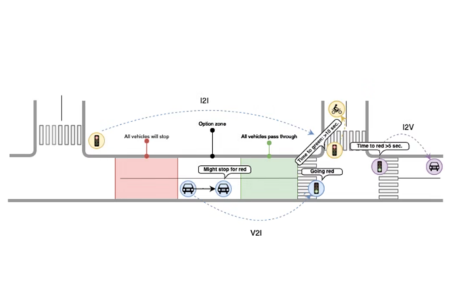
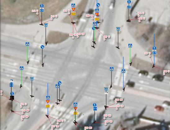
First, data is collected to detect road crossings. Later, the intention was to send alerts nearby drivers to prevent a potential collision but due insufficient amount of data and users, the pilot did not proceed to the next phases.

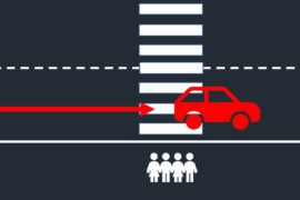
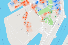
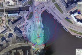
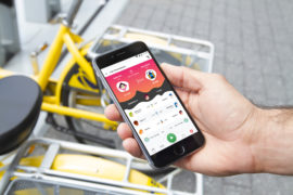
The technology can alert drivers even if the pedestrian is located behind an obstacle and the driver can’t see him. The incident data can also be used by the city itself to improve the city road safety infrastructure. Jätkäsaari Mobility Lab supports the pilot by helping in finding test users to use the application which is available both for Android and iOS. The application also utilises Helsinki’s open data to map whether road crossings are done at crosswalks or traffic lights. 

Key functionalities that were planned:

Pedestrian mode

– Road safety behavior stats to improve on-road behavior
– Real-time alert in case the user watches the smartphone when approaching a road
– Volume control – Adjusting headphones volume near roads

Driver mode

– Collision detection alert – Alert drivers on possible collision with pedestrians, even when the pedestrian is behind obstacles and the driver cannot see him
– Alerting drivers in possible collision situations
– Real-time notification when entering crowded pedestrian areas

City road safety dashboard

– Aggregated and statistical data for the city for better planning the physical infrastructure for pedestrians’ road safety (e.g. crosswalk planning, bicycle trails, traffic light optimization)

Radar view of Jätkäsaari Smart Junction

Jätkäsaari Smart Junction

  • Conveqs
  • Aalto University
  • Port of Helsinki
  • City of Helsinki
  • PHOTO: Ramboll Finland Oy

Jätkäsaari Smart Junction project improves the traffic situation awareness and develops simulation models for optimizing traffic lights for better traffic fluency. It uses cameras and radars installed at the intersections from the bottleneck of Mechelininkatu/Hietalahdenkatu and Jätkäsaarenlaituri towards Länsiväylä. The radar data can be used by third parties as well.

Goals

Generate open data on traffic situation for third parties, and using this data to find ways of improving traffic fluency in the harbour area with the help of AI.

Duration

Q4/2019 - Q4/2021 - and continued Q1/2022 onwards

Funding

59 500€ from Jätkäsaari Mobility Lab for equipment procurement, installation and consultation services for the opening of data + investments in traffic monitoring sensors. 50 000€ from Port of Helsinki for AI based traffic optimization solutions.

Contacts

Mikko Lehtonen (City of Helsinki)

This data feeds to further research on possibilities to improve traffic fluency with the help of traffic signal optimization based on the application of AI. The area monitored by the first setup near the Clarion hotel is illustrated in this image of the installation, camera view and radar. Open data from the radars is available for third party development purposes, more information on it can be found here.

Two people lying in show with fatbikes next to them

UIA HOPE – Air quality

  • City of Helsinki; Forum Virium Helsinki
  • University of Helsinki; Vaisala Plc
  • Helsinki Region Environmental Services
  • Finnish Meteorological Institute
  • Useless Company Ltd

HOPE empowers citizens to develop their own neighbourhoods with differing air quality challenges. Engaging citizens improves the data available and the relevance of the mitigation activities.

GOALS

Change that the project wants to achieve is that citizens find air quality issues easily relatable and understandable.

Timetable

11/2018 - 04/2022

Budget

Total ERDF budget granted EUR 4,561,260.28

Contact Jussi Kulonpalo (City of Helsinki)

Project focuses on port-related traffic in Jätkäsaari, street canyons and 40K daily vehicles in Mäkelänkatu-Kumpula area, and domestic wood-burning in combination with adjacent main roads in Pakila.

The overall challenge is that measuring, analysis and dissemination of air quality data in any given location is very complicated and contaminated with error. Lack of real-time and reliable high resolution data has led to a situation where finding targeted interventions that take into account our citizens and their needs while also targeting specific pollution concentrations is missing for all European cities.

Mobile phone with an open MUV application shown in the hand of a user

Mobility Urban Values – MUV

Photo: Mobility Urban Values

Finished Q2/2020 The Mobility Urban Values (MUV) project encourages residents to change their mobility behaviour and make more sustainable mobility choices through illustration and gamification.

Goals

The MUV system will result from the combination of behavioural change techniques, new technologies, data science and co-design approaches.

Duration

1.7.2017-31.5.2020

Funding

The project has received funding from European Union's Horizon 2020 research and innovation programme.

Contacts

Sami Sahala (Forum Virium Helsinki)

The project’s influencing methods are co-created with residents. At the same time, the project creates tools for both residents and data collection, thus facilitating local-level city planning.

Traffic jam in Jätkäsaari

Traffic Situational Picture

  • Infotripla Oy
  • City of Helsinki
  • Port of Helsinki

Solution developed by Infotripla integrates data from several sources, incl. vehicle calculation sensors, providing tools and increased awareness for traffic management to address congestion peaks resulting from ferry traffic.  

Goals

Improved situational picture and tools for traffic managers as well as open data and information for third parties.

Duration

Q3/2019 - Q4/2022

Funding

100k€, funded as part of the Jätkäsaari Mobility Lab.

Contacts

Mikko Lehtonen (City of Helsinki)

Related open data and APIs: https://helsinki.liikennenyt.fi/opendata/

As continuation for a FinEst Smart Mobility innovation pilot, a traffic situational picture solution is implemented in West Harbour. The project produces open data and information for third parties, such as traffic events and road incidents in the area, traffic congestion, route recommendations as well as the number of vehicles arriving through the harbour gates.

Bercman pedestrian crossing traffic sign in autumn

Smart Pedestrian Crossing

  • Bercman Technologies
  • Forum Virium Helsinki
  • PHOTO: Juho Kostiainen

COMPLETED Q1/2020. The smart pedestrian crossing was one of the agile pilots of the Last Mile project.  

Generating data that can be used for better planning of the city environment and improving traffic safety.

Schedule During 2019

The pilot is funded as part of the Perille Asti project.

Contact Heli Ponto, Forum Virium

Apart from enhanced visibility, the smart traffic sign includes technology that generates data on traffic volumes, speed, air quality and environmental conditions for transport and city planners.